
EcoCatch
Advanced Marine Pollution Monitoring & Analysis
An AI-powered environmental monitoring system that detects harmful algal blooms and microplastic pollution using satellite data and machine learning.
Project Overview
Revolutionizing marine ecosystem monitoring through advanced remote sensing and AI technologies
EcoCatch is an advanced environmental monitoring system designed to analyze and mitigate marine pollution through the integration of remote sensing, artificial intelligence, and ecological modeling. By combining data from multiple satellite sources and ground validation, EcoCatch provides unprecedented insights into marine ecosystem health.
Multi-Source Satellite Data
Integrates Sentinel-2 MSI, Sentinel-3 OLCI, MODIS-Aqua, and EMODnet datasets
AI-Powered Analysis
Machine learning models for pollution detection and prediction
Marine Ecosystem Focus
Specialized in harmful algal blooms and microplastic pollution tracking
Technology Stack
Cutting-edge tools and platforms powering EcoCatch's environmental intelligence
Data Sources
Processing & Analysis
Scientific Methodology
Validated approaches for marine pollution detection and analysis
EcoCatch employs a scientifically rigorous methodology that combines satellite remote sensing with in-situ validation data to monitor and predict marine pollution patterns.
Data Acquisition
Collection of multi-spectral satellite imagery from Sentinel and MODIS platforms, combined with EMODnet ground truth data.
Preprocessing
Atmospheric correction, cloud masking, and geometric calibration to ensure data quality and consistency.
Feature Extraction
Identification of spectral signatures for chlorophyll-a concentrations and algal bloom detection.
AI Analysis
Machine learning algorithms correlate spectral data with microplastic concentrations (R²=0.89 validation).
Visualization & Reporting
Generation of interactive maps, heatmaps, and predictive models for stakeholders and policymakers.
Scientific Validation
Key Features
Comprehensive capabilities for marine environmental monitoring
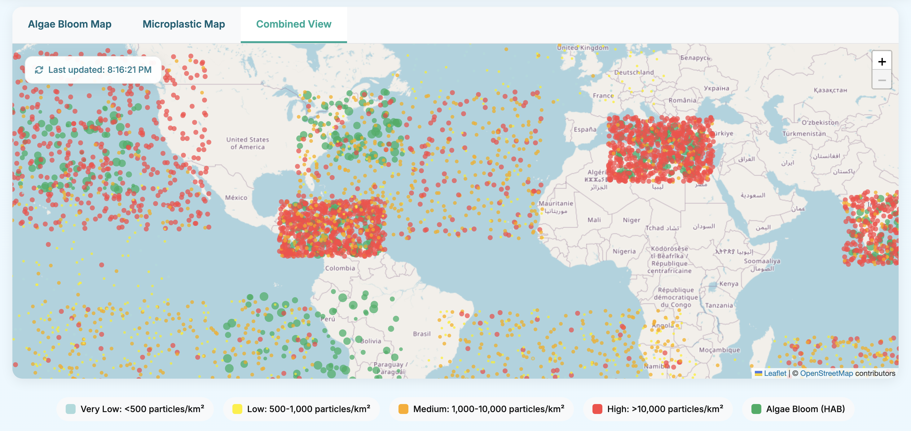
Global Microplastic Distribution Mapping
Visualize microplastic concentrations derived from algae bloom data using validated correlation models with R²=0.89 correlation with EMODnet validation data.
Harmful Algal Bloom Detection
Monitor and track harmful algal blooms (HABs) using chlorophyll-a concentration data from Sentinel-3 OLCI imaging with 92% accuracy.
Pollution Trend Analysis
Identify and analyze microplastic pollution trends through advanced correlation algorithms and historical data comparison.
Predictive Modeling
Forecast pollution spread and impact on marine biodiversity using machine learning models trained on extensive datasets.
Environmental Factor Integration
Incorporate sea surface temperature, ocean currents, and regional coefficients into microplastic concentration calculations.
Interactive Data Visualization
Access user-friendly interactive maps, heatmaps, and data exploration tools for comprehensive environmental analysis.
Implementation & Results
Real-world application and measurable impact of EcoCatch technology
Project Impact
Since its implementation, EcoCatch has provided critical insights into marine pollution patterns, enabling more effective conservation strategies and policy decisions.
Case Studies
Mediterranean Sea Monitoring
EcoCatch identified 342 high-risk microplastic accumulation zones in the Mediterranean, leading to targeted clean-up initiatives and policy recommendations.
North Atlantic Gyre Analysis
Detailed tracking of plastic pollution patterns in the North Atlantic Gyre revealed seasonal variations and accumulation hotspots.
Future Roadmap
Strategic development plan for EcoCatch over the next five years
Phase 1: Platform Enhancement
- Integration of real-time data from Copernicus Marine Service
- Refinement of microplastic classification algorithms
- Expansion of API access for research institutions
- Mobile application development
Phase 2: Global Expansion
- Extension to additional marine regions and coastal areas
- Partnerships with 10+ international research organizations
- Implementation of predictive modeling for fishery impacts
- Development of educational modules for universities
Phase 3: Advanced Analytics
- Integration of additional satellite data sources
- Development of climate change impact models
- AI-powered recommendation system for policymakers
- Real-time alert system for environmental agencies
Phase 4: Ecosystem Integration
- Development of comprehensive marine health index
- Integration with global conservation initiatives
- Expansion to freshwater system monitoring
- Implementation of blockchain for data transparency
Phase 5: Global Impact
- Establishment as global standard for marine pollution monitoring
- Partnership with UN Environmental Programme
- Development of automated policy recommendation engine
- Expansion to atmospheric plastic pollution tracking
Team & Collaboration
The minds behind EcoCatch and our network of partners
EcoCatch is developed by a multidisciplinary team of environmental scientists, data analysts, and software engineers committed to advancing marine conservation through technology.
Elizya Sandıkçı
Specializes in remote sensing applications for marine ecosystem monitoring and AI-driven environmental analysis.
Research Team
Multidisciplinary team with expertise in satellite data processing, machine learning, and marine ecology.
Collaborations & Partnerships
Publications & Resources
Scientific research and resources supporting EcoCatch methodology
Spatial and temporal distributions of microplastics and their macroscopic relationship with algal blooms in Chaohu Lake, China
The interaction between plastics and microalgae affects community assembly and nutrient availability
Coexistence of cyanobacteria and microplastics in eutrophic lake ecosystems: Interactions and combined effects
Data Resources
Join Our Mission
Help us expand EcoCatch's impact on global marine conservation efforts